What was Lahun (Kahun) in ancient Egypt? Lahun was a planned Middle Kingdom settlement near the pyramid complex of Senusret II at the entrance to the Fayum. Excavated by Flinders Petrie, its street plan, small and large houses, tools and papyri reveal how a royal-associated community lived and worked. The modern name Kahun is commonly associated with the ancient town, but the evidence comes from varied houses, documents and archaeological contexts rather than one fully preserved family history.
Ancient Lahun, often called Kahun, offers one of Egypt's richest combinations of excavated urban space and surviving Middle Kingdom paperwork. Beside Senwosret II's pyramid stood a planned town with dramatically different house sizes, work routines and administrative papers recovered in early excavations. Barry J. Kemp's Anatomy of a Civilization raises the larger question of how formal planning shaped society; the evidence from UCL's Petrie Museum lets us test it without imagining the people as identical pyramid builders. This source-led investigation follows streets, homes, a rubbish archive and modest everyday possessions, with separately identified modern site photographs.
The town was a plan before it became an excavation
The settlement now called Lahun or Kahun offers a rare opportunity: we can investigate how an Egyptian town was organized before we speculate about what its residents believed. A plan traced from mudbrick walls suggests deliberate grouping of streets and dwellings close to Senwosret II's pyramid complex. Barry Kemp discusses planned settlements and the relationship between residential forms and social organization, including examples whose excavated layouts seem startlingly systematic.
The temptation is to imagine a perfect top-down city built in a single day by a ruler with a drafting board. The archaeology is less tidy. Buildings can be modified, streets extended and houses reused. A plan preserves what an excavation recorded, not every stage of life before the site was abandoned. At Lahun this challenge is intensified by nineteenth-century methods of clearance. The site nonetheless supplies one of the clearest windows into the Middle Kingdom's built environment, and an unusually rich archive of papyri makes it possible to move between architecture and the work of actual administrators.
Why the town is called Kahun as well as Lahun
The modern site name is el-Lahun, near the entrance to the Fayum. Flinders Petrie used Kahun for the settlement he excavated in the late nineteenth century, and many older works retained that designation. UCL's Digital Egypt identifies the likely ancient town name as Hetep-Senusret, although modern usage still distinguishes the settlement, pyramid and surrounding cemeteries in different ways.
Terminology is not merely a spelling preference. A visitor can find photographs of the nearby pyramid without seeing the excavated streets of the town, while a museum object recorded as 'Kahun' may come from the former residential area rather than the royal pyramid itself. Captions must preserve that distinction. The settlement's associated dates belong mainly to the later Twelfth and early Thirteenth Dynasties, with reuse in other periods. The precise span of any one household's occupation is not established by the broad site date. Nor should everyone who lived in the town automatically be called a pyramid builder. The evidence includes officials, families, workers and temple administration beyond the initial royal construction project.
The small houses and the large houses
The site's plan distinguishes densely arranged small dwellings in one area from much larger houses organized around courts in another. UCL's Petrie Museum explains that the differences in scale reflect considerable social variation. A planned community was not therefore a uniform settlement of equally housed workers.
A larger house could contain spaces for reception, storage, domestic preparation and members of an extended household. Smaller units constrained movement in different ways. But room count is not a direct measure of wealth, gender, freedom or household size. Some spaces could be occupied by servants and dependents whose names never appear in a surviving deed. A ruler's provision of accommodation also does not prove that all inhabitants had equal access to provisions. The important result is that inequality is legible in the plan before we read a single elite inscription. That does not mean the excavated architecture explains every social relationship. We should compare building sizes with the uneven records of personal possessions, correspondence and administrative responsibilities.
Streets as instruments of organization
Straight routes and clustered residential blocks made movement and oversight possible within the walled settlement. A central dividing line appears in modern plans, although historians debate how much can be concluded about strict administrative segregation from the surviving walls. One should resist claiming that an official checked every resident's permission at a gate unless documentary evidence identifies that practice.
What the plan can show is spatial differentiation: some houses are grouped closely, while others occupy generous compounds. Paths connect homes to workplaces and to areas used for services. These decisions create habitual movements that could influence the social life of a neighborhood. Yet a street cannot reveal the precise conversations that took place on it. No modern photorealistic rendering can recreate the unrecorded social history with certainty. Kemp's interest in urban forms is a guide to framing the problem, and the actual excavated plan remains the evidence. In this article a genuine site photograph is labeled as a present-day ruin, not as a picture of a bustling Middle Kingdom avenue.
A town with an archive in the rubbish
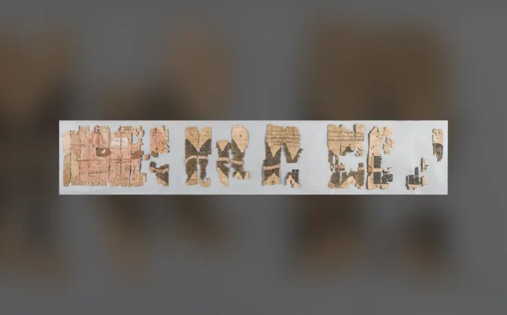
Lahun is exceptional because manuscripts survived alongside domestic objects. UCL reports that Petrie's work between 1889 and 1899 recovered one of the largest bodies of Middle Kingdom papyri then known. Two broad groups require distinction: business papers linked to Senwosret II's cult, and more varied material rescued from across the town site.
Some papers came from a rubbish mound near the valley temple. The context is historically revealing. Documents were objects with useful lives; they could eventually be discarded, and their preservation depended on environment and chance. A sheet no longer needed by its owner could become a unique modern witness to an ancient institution. But manuscripts found in a dump are not automatically a perfectly ordered archive of one office. Individual pages may have arrived at the deposit through separate processes. Dating, handwriting and content must be compared. The presence of administrative text proves that some inhabitants wrote and kept records, not that every person living behind the mudbrick walls was literate.
Counting fields and counting things
The Lahun papyri include an administrative account about a journey to count fields and a list of objects from the town treasury, catalogued by UCL among its accounting documents. Another text concerns travel to the Residence for counting at the head of the year. These entries indicate that information about fields and resources could move between local management and larger institutions.
The terms count, treasury and residence have specific ancient administrative contexts. A record of measuring or checking land is not a modern property-tax return in a familiar bureaucratic format. It may concern assets, revenue obligations or responsibilities of an office. A surviving text can establish the task written down, but not every later action carried out because of it. It also does not establish one annual census of every Egyptian field. Kemp's broad question about state capacity gains precision here: administrators needed to know, or at least claim to know, what resources were where. Lahun offers named documents for testing that connection instead of an abstract claim that Egyptian rulers simply owned everything.
Rotating crews and named work projects
UCL lists a phyle-exchange formula and a roster of names for a work project among the Lahun manuscripts. A phyle was a group or rotation within institutional service, though particular arrangements changed by period and office. The records make it possible to ask how labor was divided, relieved and represented on paper.
It would be too simple to call the whole settlement one barracks staffed with permanently conscripted laborers. The documents capture multiple types of responsibility. Some inhabitants likely lived with families, and a person's membership in a named group does not tell us the legal circumstances of every work assignment. A list can reveal an expectation without supplying the worker's perspective or an individual pay rate. Even the recurrence of a familiar name may not prove that every reference identifies the same person. By making those limitations explicit we can still explain why scheduling mattered: royal complexes and mortuary cults required recurrent activities long after the immediate construction project was complete.
The town's women are not invisible in the texts
The Petrie Museum's Lahun collection includes legal, personal and practical manuscripts that can illuminate women's participation in family life and property arrangements. One example is a conveyance associated with a man named Mery; other material includes letters and healing prescriptions. These texts should be read individually rather than cited as though they prove unrestricted equality between all ancient women and men.
Written records are selective. People who could initiate or preserve a formal transaction are more visible than those whose labor never generated surviving paperwork. An inventory might list an object connected to a household but not tell us who used it most frequently. The building plan adds context without supplying personal biographies. The most responsible social history asks which kinds of transactions appear, which names and roles recur, and which questions remain unanswered. A city can be planned from above while its inhabitants continue to negotiate obligations at the scale of families. That tension is more illuminating than a generic sentence claiming that ancient Egyptians enjoyed comfortable houses.
Objects too ordinary to be royal treasures
Petrie's excavations recovered everyday items such as tools, gaming pieces and objects used in personal grooming. UCL's modern display highlights a black faience gaming piece, a wooden cubit measure, hair curlers and possible evidence of rodent control. These humble items widen the town's story beyond architecture.
A wooden measure suggests activities requiring standardized dimensions, but it does not say whether a named resident used it to construct the pyramid. A gaming piece shows the presence of recreation or game-related material culture, not a complete preserved set of rules. A possible rat trap deserves the word possible until the identification is independently tested. That small adjective is the difference between archaeology and a catalogue of appealing guesses. The archaeological record contains many objects that may be understood through wear, parallels and context rather than a written label. These finds help a visitor imagine work and leisure without turning every artifact into a fictional scene.
What the pyramid contributes to the town's story
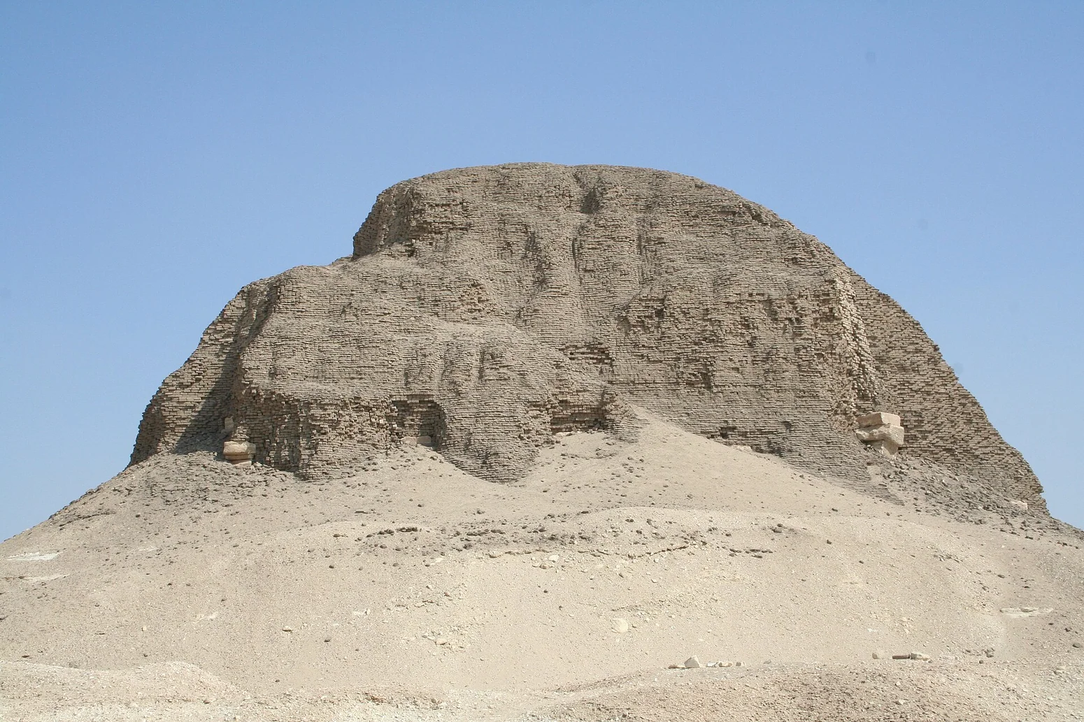
Senwosret II's pyramid at Lahun was built at the desert edge overlooking the Fayum entrance. It represents a royal investment around which settlement, administration and cult duties could develop. The photograph paired with this essay is an authentic modern view of the pyramid's mudbrick remains, not a photograph of the old residential plan.
The pyramid and the town belong together historically, but they do not mean exactly the same thing. One memorialized kingship in monumental form; the other contained spaces where people lived and performed practical responsibilities. The surviving papyri connect the royal cult with continuing service beyond the king's death. This avoids a common chronology error: calling all Lahun documents a direct report from the day the pyramid's first bricks were laid. A cult establishment could maintain obligations for decades afterward, and the surviving papers often date to succeeding rulers. A successful article makes that extended institutional life visible rather than freezing the settlement in one picturesque construction season.
Petrie's excavation is evidence and a limitation
Lahun was cleared in 1889, at a time when archaeological recordkeeping differed greatly from current methods. UCL cautions that the exact findspots of many small objects were only occasionally recorded. This limits attempts to assign a particular game or household tool to a particular room or resident.
The site's early documentation remains immensely useful, especially plans and recorded objects that might otherwise have disappeared. Yet later scholars must work with missing context that a modern excavation would seek to preserve. An attractive plan can give a false impression of complete certainty, because not every wall line was necessarily contemporary and not every room's contents were recorded in a stratigraphic sequence. The responsible response is neither to discard Petrie's achievements nor to treat his published reconstruction as a flawless photograph. We can compare his plan with current site observations, museum records and new archaeological surveys. Learning from the history of excavation is part of learning about the town itself.
A photograph of the ruins tells only part of the truth
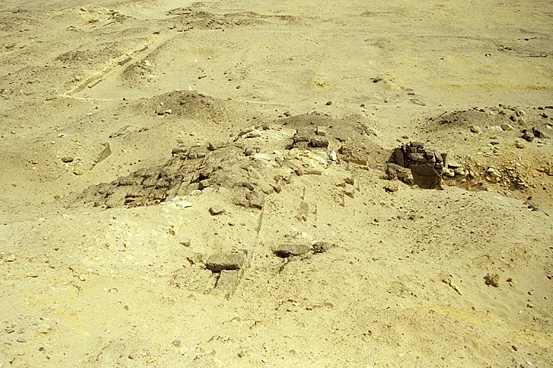
The first licensed photograph shows the surviving settlement of Kahun at Lahun, photographed by Roland Unger in 2003. It depicts real ancient remains in a modern desert landscape. A second genuine photograph by Einsamer Schütze shows Senwosret II's pyramid nearby, recorded in 2006. Each receives its own date and attribution.
Neither photograph reproduces the town before its houses lost their roofs, nor does it identify a school, kitchen or official's bedchamber without further archaeological documentation. The original town plan and actual papyri must supply those interpretations. We deliberately avoid using an imaginative illustrated city reconstruction as if it were a period visual source. The historic map of Lahun in Kemp's discussion remains a scholarly diagram from previous research, not an image the modern site photographer somehow captured. That separation lets readers enjoy the landscape without losing track of how archaeology produces knowledge.
The life of a planned town extends beyond one reign
Although the settlement's creation is associated with Senwosret II, many papyri and objects belong to later Middle Kingdom generations. Some residents served royal cults or administrative institutions whose obligations endured. Later reuse further complicates the site's occupation history. A town could be established through concentrated royal authority yet acquire a social history not fully controlled by its founder.
A house might pass between occupants, be modified or change function. A cult might demand continuing supplies even after its original patron's death. A scribe's discarded account could outlast a wall and eventually survive thousands of years under dry sand. The site therefore challenges two caricatures of Egyptian society: the notion of a fully uniform population marching to royal commands, and the opposite assumption that official planning left no mark on ordinary life. Both plan and papyrus survive, allowing historians to ask how organization shaped opportunities and inequalities.
Lahun as a laboratory of ancient urban history
What makes Lahun extraordinary is the encounter between planned space and surviving written traces. The rectangular settlement, unequal dwelling sizes and associated pyramid indicate a deliberate institutional setting. The papyri disclose field counting, assignments, property arrangements, personal matters and cult administration. The objects record activities that some documents ignore.
These sources illuminate one another without collapsing into a single universal model. We cannot reconstruct the exact voice of every laborer, the income of every household or the full itinerary of one ancient resident. Nor can we turn one town's plan into the template for every Egyptian city. Barry Kemp's larger study of settlements and institutions shows why the question is worth asking, while UCL's papyri and archaeological publications give it testable content. The most useful conclusion is that the Egyptian state was experienced materially: in the size of a home, in a trip to count fields, and in the papers once discarded outside a temple. Architecture made administration visible, and everyday objects give the planned lines a human scale.
Evidence at a glance
| Evidence | What can be concluded |
|---|---|
| UCL site plan | Deliberate layout with both large compounds and groups of modest dwellings. |
| Lahun royal cult papers | Accounts from the king's cult after Senwosret II, not a construction-day journal. |
| Town manuscripts | Legal, business, personal and medical material, found through Petrie's late nineteenth-century clearance. |
| Petrie's excavation context | Important plans and artifacts, but exact finds for many small objects were not recorded. |
| Two modern photographs | One shows the town's ruins; the other the nearby pyramid, both carefully distinguished. |
Frequently asked questions
Was Lahun built for pyramid workers?
The town was closely associated with Senwosret II's pyramid and its institutions, but it housed diverse people and continued in use after the initial building project.
Are Kahun and Lahun the same site?
Kahun is Petrie's widely used name for the ancient settlement; Lahun is the modern geographic place name covering the town and pyramid area.
Do the houses prove all residents were equal?
No. The surviving plan shows major differences in dwelling size, though precise status and household composition require additional evidence.
Where can original papyri be studied?
UCL's Petrie Museum and Digital Egypt publish catalogued examples. Other cult documents from Lahun are held in institutions including Berlin and Cairo.
Sources and image provenance
This article uses the historical source listed in the bibliography as a research starting point, specifically PDF pages Barry J. Kemp, Anatomy of a Civilization, supplied Arabic translation, PDF p.383 (illustrated plan of Kahun/Lahun and associated Middle Kingdom urban-planning discussion); museum evidence independently checked with UCL.. Its historical rhetoric and older interpretations are not treated as conclusive archaeological evidence. The external museum and research records below are linked for independent checking.
- UCL Digital Egypt, original Lahun town plan and daily-life finds
- UCL Petrie Museum: One Day in Lahun (house sizes and ordinary objects)
- UCL Digital Egypt: Lahun papyri and catalogued Middle Kingdom administrative records
- UCL: Lahun in Middle Kingdom, names and chronology
- UCL Digital Egypt: Lahun place name and excavation historiography
- Original Commons 2003 Kahun settlement documentary photograph
- Original Commons 2006 Lahun pyramid documentary photograph
- Photograph: Original photograph of Lahun/Kahun ancient town ruins by Roland Unger, 4 March 2003, CC BY-SA 3.0. A surviving site view, not a reconstruction of occupied streets., Roland Unger, genuine Lahun settlement photograph taken 4 March 2003, CC BY-SA 3.0
- Photograph: Authentic 2006 photographic view of Senwosret II's pyramid at Lahun by Einsamer Schütze, CC BY-SA 3.0; this is the nearby royal monument, NOT a view of the town's individual houses., Einsamer Schütze, actual 14 September 2006 photograph of Senwosret II's pyramid, CC BY-SA 3.0