Abu Simbel’s survival was one of the most extraordinary engineering and heritage rescue operations of the twentieth century. But the story is bigger than an ancient monument lifted onto new foundations. In the 1960s, the Aswan High Dam threatened Nubian archaeological landscapes and the homes of living communities. Egypt and Sudan requested international help, and UNESCO coordinated the rescue of major temples, including Abu Simbel, amid widespread excavation and resettlement.
This Kemet Vault encyclopedia reconstructs the campaign from its 1959 request and 1960 appeal to the moving of immense sandstone blocks, the 1968 reopening, the later Philae relocation and the official conclusion in 1980. Four original UNESCO archive photographs show real dismantling and reconstruction. Scholarly evidence explains the human consequences rather than pretending that saving stone made every problem disappear.
A pharaonic temple rescued in the age of modern dams
In the twentieth century, the temples of Abu Simbel faced a threat very different from the sand and erosion they had survived for thousands of years. Egypt’s Aswan High Dam project would create a reservoir rising over the original location of the rock-cut sanctuary built for Ramesses II. The dilemma joined modern development and ancient heritage in one landscape. Governments wanted new power and greater control of the Nile; archaeologists and conservators feared irreversible loss; Nubian families faced major changes to their homes, land and social geography. In response, Egypt and Sudan worked with UNESCO to mobilize an international campaign beginning in 1960. The rescue would relocate major temples and document numerous endangered sites. The largest photographic spectacle was the cutting and reassembly of Abu Simbel’s colossal statues. But a responsible history must include the historical inhabitants of Nubia, not only the ancient kings whose monuments became world-famous. UNESCO’s documents, the Egyptian antiquities ministry and historical scholarship make it possible to study the decision, engineering and social consequences without collapsing them into an uncomplicated triumph. This article is not a travel itinerary: it investigates a modern conservation emergency whose achievements and costs continue to shape how heritage is understood.
1954: the High Dam decision and a changing Nile landscape
UNESCO’s campaign history dates the decision to build the Aswan High Dam to 1954. The proposed reservoir would flood a long section of the Upper Nile from Egypt into Sudan, including an exceptionally rich archaeological region known as Nubia. The dam was part of Egyptian state planning for large-scale water control and electricity generation, although its economic and environmental consequences remain subjects of historical and technical analysis. It is misleading to explain the decision as solely an attack on archaeology or as a policy intended only to create a museum. The dam had contemporary goals that supporters presented as central to development. At the same time, the intended water levels would transform the land used by villages, farmers and communities as well as the physical setting of ancient monuments. The issues cannot be separated neatly: rocks quarried or moved for modern construction and blocks rescued from archaeological sites were part of the same changing environment. Oxford historian Nancy Y. Reynolds emphasizes how landscape transformation and Nubian claims about relocation were closely intertwined. A heritage account should therefore begin with the geographical scale of the proposed lake, not with an isolated image of an engineer holding a measuring tape.
Egypt and Sudan’s 1959 request to UNESCO
Egypt and Sudan asked UNESCO in 1959 to help protect endangered archaeological remains and sites. The request made international collaboration possible before the water reached all the threatened areas. It is important to identify both governments because the flooded archaeological landscape did not end at Egypt’s modern border. Nubian heritage spans regions now lying in two states, and archaeological work in Sudan formed part of the broader emergency. UNESCO took on an unusual coordinating role, helping connect donor governments, technical experts, archaeological institutions and the two states. In 1960 its Director-General publicly appealed for international support, while governance structures including an Executive Committee and a dedicated fund were established. Such administrative mechanisms are easily overlooked in popular stories, but they mattered: teams could not relocate vast monuments simply through goodwill or dramatic television coverage. They required budgets, legal permissions, surveys and procedures for working across borders. It was an enormous test of international heritage cooperation during a politically divided world. At the same time, the inclusion of international specialists should not obscure the role of Egyptian and Sudanese professionals and workers. International cooperation operated through institutions and people whose interests and responsibilities were not always identical.
1960: a worldwide campaign with local consequences
The UNESCO appeal turned the monuments of Nubia into an internationally recognized conservation cause. National committees, scholars, engineers and donors began organizing support. Large archaeological expeditions intensified surveys and excavations in threatened areas. The global public heard about dramatic temples facing destruction, creating political and financial momentum behind the works. UNESCO later reported the rescue of 22 monuments and complexes through the efforts of 40 technical missions from five continents, alongside extensive documentation of other sites. These numbers refer to the whole campaign, not a claim that exactly 22 temples were cut apart like Abu Simbel. Some were relocated in other ways; others were documented, studied or salvaged as collections. The operation did not preserve every endangered object, tomb, village or landscape feature. That limit matters because promotional accounts sometimes blur extraordinary successes with total preservation. In parallel, communities experienced uncertainty about resettlement and compensation as the reservoir advanced. The story of Nubia after 1960 is therefore two connected narratives: monumental heritage rescue and the transformation of inhabited territory. UNESCO’s official account emphasizes the former, while environmental and social historians reconstruct the latter from residents’ demands and administrative records.
What was actually threatened at Abu Simbel?
The Great Temple of Abu Simbel was carved into rock under Ramesses II in the nineteenth Dynasty, while a smaller temple nearby was dedicated to Hathor and the king’s Great Royal Wife Nefertari. Their original setting was part of the Nile-side sandstone landscape of southern Egypt. The four seated colossal figures of Ramesses II on the Great Temple façade are famous, but the protected object was much more than those visible faces. Engineers had to consider a rock-cut interior, chambers, reliefs, the relative positions of sacred spaces and the smaller temple as well. The Egyptian Ministry describes the ancient sanctuary and its solar alignment, including annual illumination of inner statues. Those ancient architectural relationships added difficulty to the rescue. Saving only a recognizable façade while discarding the interior would have destroyed essential historical evidence. Yet rebuilding the temple in a newly created cliff would necessarily alter its relationship to the original land and river. Archaeological integrity is not an all-or-nothing property: some structures and alignments could be protected, while other aspects of context would be lost. The project shows why conservation decisions must define what they are trying to preserve before construction begins.
What did the engineers have to solve?
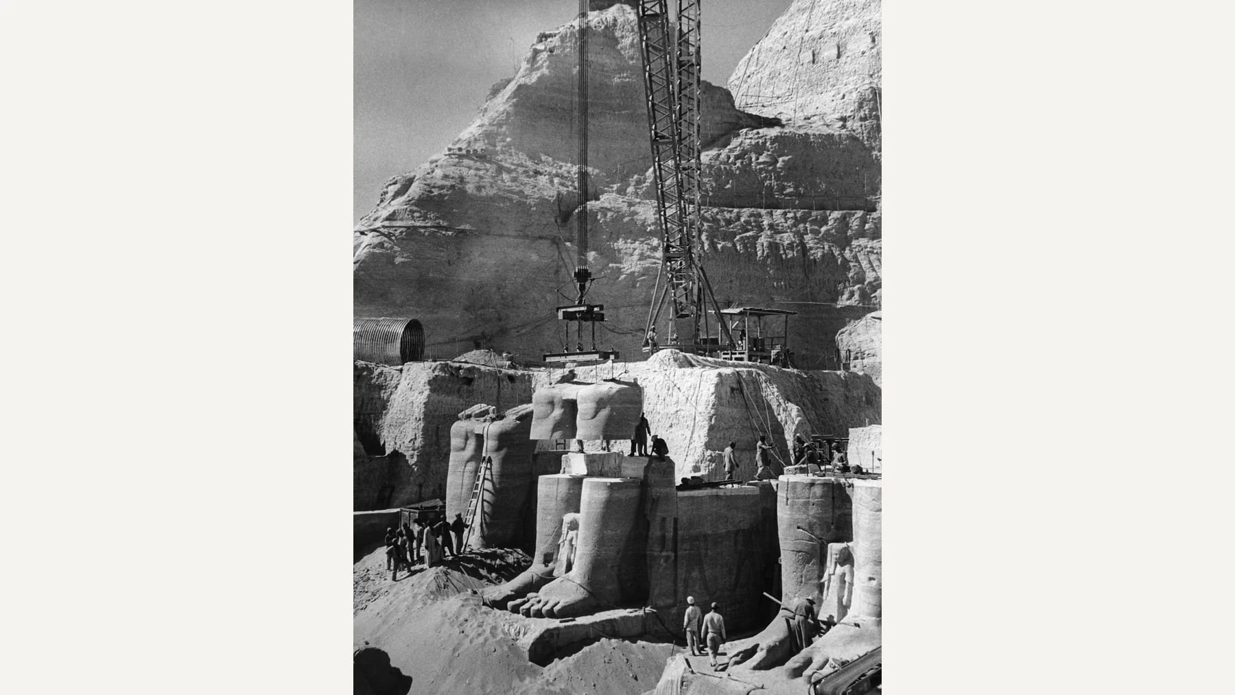
A workable rescue required moving enormous masses of sandstone while protecting sculptures and decorated interior surfaces. Specialists considered approaches ranging from physical barriers against flooding to other methods of relocation. The eventual decision was to cut the temples into manageable blocks, number the pieces, transport them and reconstruct them on higher ground. That procedure is often described as simply “moving the mountain,” but the real work depended on surveys, protection of fragile surfaces, control of cutting vibration, cranes, scaffolding, supporting structures and documentation. The shape of the restored façade had to be reconstructed with careful attention to seams and orientation. Transport itself created risks: a stone that fractured during lifting could irreversibly damage an ancient inscription or royal face. UNESCO reports that workers using wire saws began cutting in November 1963, then moved over a thousand numbered blocks averaging about 30 tonnes each. These descriptions are official project-level summaries, not a claim that every block had identical weight. The rescue depended on engineering calculations and skilled labor, but it also rested on the archaeological knowledge that guided where cuts could safely pass. An outcome that now looks seamless was achieved through a dangerous sequence of individual decisions.
1963–1966: dismantling a monument without destroying its images
The physical dismantling of the Great Temple required attention to both the visible colossal heads and the less obvious decorated walls behind them. The international campaign’s archive contains photographs of cutting operations, temporary structures and sandstone blocks being handled by machinery. Unlike a digital reconstruction, an original photograph records actual workers, equipment and material at a specific stage of the project. Yet even here, a photo’s date may reflect a cataloguing convention rather than an exact day of exposure. The UNESCO photograph below is associated with the dismantling of the Great Temple’s statues during 1966. It shows the stark reality behind a monument now encountered as an apparently whole cliff: pieces had to be separated deliberately for survival. Conservation ethics were challenging because the operation damaged original geological continuity in order to avoid total submersion. That trade-off is important, and it cannot be understood from a triumphant finished photograph alone. Every cut produced a record of an intervention as well as a risk to ancient sculpture. Researchers and engineers had to decide what constituted an acceptable alteration, balancing the practical limits of machinery against the need to preserve visual and spatial meaning. The completed monument still carries physical evidence of those mid-twentieth-century decisions.
The hidden project: lifting, numbering, storing and rebuilding
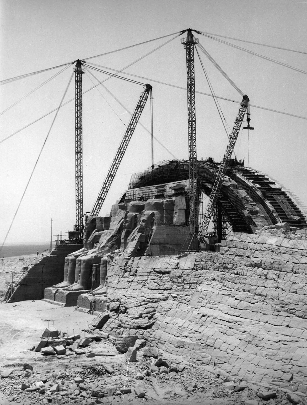
Once blocks were separated, the workforce faced the immense logistical task of moving them to a different site and reassembling them in a comprehensible order. A system of recording and numbering was indispensable because misplaced or badly aligned blocks could change the contours of the temple’s sculpted architecture. Teams built new supporting structures, moved materials through staging areas and used precision measurements to check the fit of elements across multiple levels. Historical photos of rebuilding make clear that the work was more like rebuilding an archaeological landscape than moving an ordinary monument in one piece. The replacement cliff was artificial, constructed to shelter the original ancient rock-cut interiors and recreate part of their monumental setting. This does not mean the ancient Egyptians built a concrete hill or that the present topography is unchanged from Ramesses II’s reign. Conservators preserved the historic temple’s stone and reliefs while introducing modern engineering to make that preservation possible. The need to distinguish original stone from supporting reconstruction remains relevant for interpretation today. UNESCO’s account reports a difficult multi-year operation rather than one continuous simple crane lift. The work demanded sustained labor, money and coordination among archaeologists, contractors and public institutions.
64 metres higher and 180 metres inland: checking the measurements
Popular descriptions of the Abu Simbel rescue often use numbers such as 65 metres higher and 200 metres back. UNESCO’s own historical overview specifies the reconstructed temples stood about 64 metres above the old site and 180 metres inland. These figures are approximate project measurements, and different publications may round or define the reference points differently. A museum-grade article should cite the chosen source and resist presenting one rounded value as a micrometre-precise survey. What matters historically is that the ancient setting was intentionally and substantially altered to escape the rising reservoir. The temples were not lifted intact on a single platform, and the new artificial cliff was not the ancient sandstone hillside in its original position. For visitors today the relocated setting can look naturally integrated with the landscape, which is a testament to the reconstruction’s visual planning. It also makes accurate signage and scholarship essential. A person cannot infer the original lake level simply by looking at the present temple steps. The relocation protected inscriptions and monumental architecture, but it inevitably changed the relationship between sacred place, riverbank and community. That is a necessary part of explaining conservation rather than an embarrassing footnote.
Protecting the sun alignment without inventing a solar miracle
The interior of the Great Temple is famous for sunlight penetrating toward the sanctuary on selected days of the year. Any relocation had to account for orientation and the building’s original spatial arrangement. The Egyptian Ministry discusses the contemporary illumination dates, given as 22 February and 22 October, and names the sanctuary figures. Such carefully recorded phenomena show how architectural design and religious symbolism can intersect, though modern explanations of the original date require caution about calendar changes, topography and the shift in location. It is tempting to claim that engineers reproduced an ancient sunrise effect without any change whatsoever. That goes further than the evidence warrants. The relocation attempted to protect an important astronomical and spatial relationship; it occurred within a newly engineered cliff and environmental setting. Claims about precise original dates, a named pharaoh’s birthday or modern alignment perfection need stronger evidence than a tourism calendar. An educational article can appreciate the engineering without replacing historical explanation with spectacle. The ritual meaning belongs to the context of New Kingdom kingship, not to an undocumented twentieth-century myth of flawless replication. Abu Simbel offers a rare opportunity to study both ancient architecture and modern decisions about what to preserve.
22 September 1968: completion and public inauguration
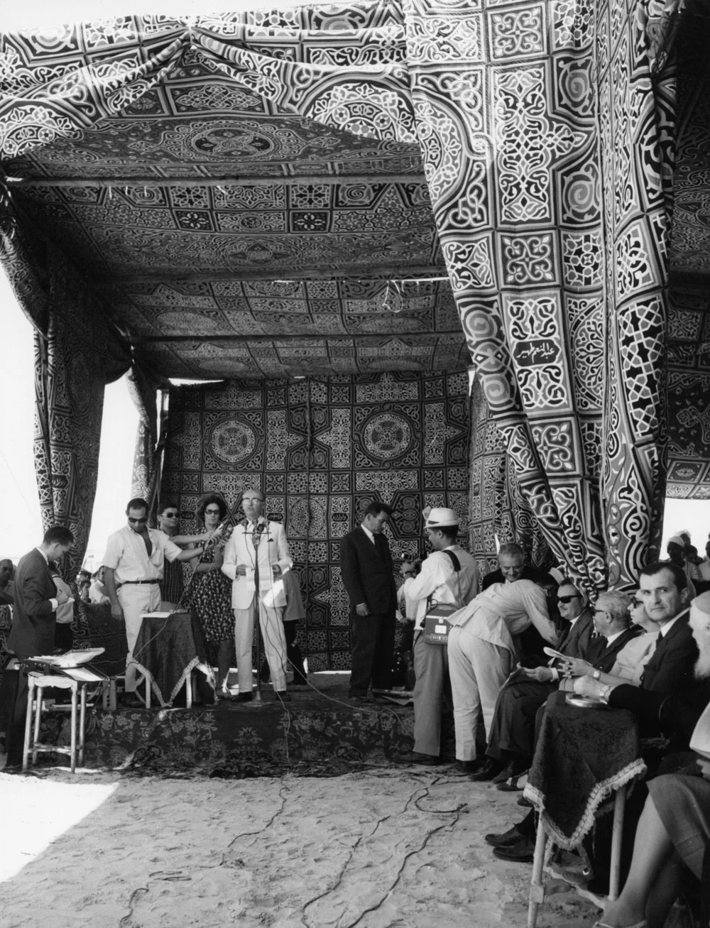
UNESCO dates the inauguration of Abu Simbel at the reconstructed site to 22 September 1968. The milestone followed years of funding, negotiation, cutting and rebuilding. Archival photographs show officials and UNESCO representatives at a ceremony marking completion of the operation. This is different from a photograph of an ancient Egyptian religious festival, and captions should not confuse it with ceremonies associated with the opening of the Suez Canal in 1869. The modern event was part of an international narrative about cultural cooperation and monumental rescue. Officials and institutional leaders were visible in the press, but their presence should not erase the workers who lifted and stabilized the stones. The ceremony marked a major project milestone rather than the end of all UNESCO work in Nubia. Other sites still required intervention, and documentation continued for years. The political significance of the event lay partly in demonstrating that states and heritage institutions could collaborate on a problem spanning international borders. The historical record must still distinguish government speeches celebrating a success from the experiences of Nubians whose original homes were being submerged. These stories occurred in the same region and period but received very different photographic attention.
Philae: a different rescue on Agilkia Island
The temples of Philae faced their own flood risks and conservation challenges. The site was part of a complicated Nile island setting near Aswan, rather than the same rock-cut landscape as Abu Simbel. UNESCO dates the transportation of Philae’s monuments to higher Agilkia Island between 1972 and 1979, making clear that the Nubian rescue did not conclude with Abu Simbel’s 1968 inauguration. The method and timetable differed because the architecture and local geography differed. Stone structures and their settings could be documented, dismantled where necessary and reassembled, but a temple built of blocks poses different engineering issues from a sanctuary cut deep into living rock. Today’s Philae is a magnificent cultural experience, yet its island location is a modern conservation setting. Visitors should not be told that the present shoreline exactly reproduces the ancient ritual approach. The separate chronology and new location also explain why comprehensive histories of the UNESCO campaign include many sites instead of focusing only on one colossal façade. Kemet Vault’s Aswan, Philae and Nubian culture guide provides visitor context; this article explains the modern preservation history that makes such a visit possible.
Beyond the showpieces: survey, excavation and lost archaeological landscapes
UNESCO’s campaign involved the recording of hundreds of sites and recovery of thousands of objects, not just the relocation of the most photogenic temples. Archaeological teams raced against rising water to document settlements, tombs, rock inscriptions and other remains. Some material was excavated and transferred to collections, while other parts of the original landscape were inevitably lost. Archaeologists face a hard distinction between saving objects and saving context. A portable stone can be moved to a museum, but its original relationship to neighboring buildings, burial deposits or local memory cannot always be reconstructed afterward. The emergency accelerated fieldwork and stimulated international collaboration, yet it also forced compromises under severe time and resource constraints. A successful rescue project does not imply that every threatened discovery was made or every scientific question answered. UNESCO’s later summary counts 22 monuments or monument complexes saved through technical missions, while other activity consisted of recording, excavation and documentation. This distinction prevents a false impression that an entire ancient region was physically moved to higher ground. Much of the intellectual importance of the campaign lies in records and publications generated before sites disappeared beneath the reservoir.
The people of Nubia and the unequal visibility of rescue
The rescue of monumental stone has been photographed and celebrated extensively, but the transformation of Nubian villages and family landscapes requires equal historical attention. Oxford historian Nancy Y. Reynolds examines Nubians who faced relocation due to the rising reservoir and who criticized compensation arrangements and resettlement plans. Her research describes appeals to move houses, saints’ shrines and gravesites with the same care granted to ancient monuments. These demands illuminate a profound issue in heritage ethics: whose history qualifies for preservation, and who gets to decide? Nubian communities were not archaeological background scenery. They possessed living languages, religious institutions, homes, agricultural practices and social networks disrupted by large-scale environmental change. Experiences varied between Egypt and Sudan and among particular villages, so it is wrong to describe one uniform response or one simple number that captures every displaced person. State-development arguments and archaeological preservation agendas could each have legitimate constituencies while leaving some residents dissatisfied or worse off. The asymmetry in international publicity was significant: images of Ramesses II’s head on a crane traveled around the world, while memories of village relocation were less prominent. A serious historical article keeps both archives visible without pretending they document identical kinds of loss.
Who did the work? Egyptian, Sudanese and international participation
The campaign involved international technical missions and donor states, with UNESCO acting as coordinator. That institutional fact should not erase Egyptian and Sudanese planners, archaeologists, craftspeople and laborers. Temples were not transported by conference resolutions. Surveyors set measurements; technicians maintained machines; stoneworkers managed difficult cuts; conservators documented fragile painted or carved surfaces; other workers arranged transportation and storage. Their individual names are not all preserved in short UNESCO summaries, but the variety of required tasks is visible in project photographs and engineering records. It is tempting to assign the entire achievement to one celebrated engineer or one country with an eye-catching headline. Such a claim would disregard how collective, extended and multinational the works were. UNESCO’s official account acknowledges contributions from numerous countries and technical missions; the Egyptian state and the local landscape were integral to the operation. Paying attention to labor also helps connect the article with Kemet Vault’s research on the builders of the nineteenth-century Suez Canal. The projects occurred a century apart and had different purposes, but each illustrates the difference between a commemorated institution and the many people doing the physical work.
The 1980 finale and the larger World Heritage movement
UNESCO records the international campaign’s official conclusion on 10 March 1980. The long chronology is essential: the better-known 1968 rescue of Abu Simbel was a critical achievement within a twenty-year preservation effort that also reached Philae and other sites. UNESCO links the campaign’s success to a broader willingness to coordinate international heritage protection and to the emergence of the World Heritage movement. The Nubian Monuments from Abu Simbel to Philae became a World Heritage property in 1979. Its components encompass more than the two most famous temples, and contemporary heritage management must consider the serial nature of the protected area. UNESCO reports approximately US$80 million in overall campaign cost, with around half donated by some fifty countries; the amounts belong to the historical project accounting and should not be presented as an equivalent current-day budget without adjustments. Follow-up initiatives included support for a Nubia Museum in Aswan and a national museum of Egyptian civilization in Cairo. The project thus changed heritage policy and public institutions as well as individual monuments. Its legacy is not a claim that future conflicts between development and conservation were permanently solved. It provided precedents for international coordination, emergency documentation and fundraising, all of which still require local accountability.

Old stones, new mountain: authenticity after reconstruction
The relocated Great Temple contains authentic ancient stone in a designed modern structural setting. It would be wrong to dismiss the entire monument as a replica; equally, it would be wrong to claim that the cliff and river perspective are unchanged since Ramesses II. Conservation theory distinguishes original fabric, archaeological context, intervention and interpretive reconstruction. Abu Simbel brings those categories together on an enormous scale. The operation preserved major architecture and decoration but displaced them from their original geological setting. Photographs taken before, during and after the move can help visitors understand which changes are modern. Visible joints may also reveal the technical intervention that made rescue possible. Those marks are part of the twentieth-century history of the site. In this sense the monument tells two major stories: New Kingdom Egyptian royal religion and modern international heritage conservation. Neither needs to displace the other. Questions about authenticity should be asked precisely: authentic sandstone and reliefs survive, while their surrounding topography was re-created to avoid flooding. By telling that history openly, heritage interpretation can respect the ancient builders and the conservation workforce alike.
Reading the UNESCO photo archive without inventing dates
The UNESCO images used here are original historical photographs released through a documented heritage-sharing partnership under a Creative Commons Attribution–ShareAlike 3.0 IGO license. They show stages of dismantling, reconstruction, the completed temple and the inauguration ceremony. The copyright metadata and the archive’s descriptions help establish their relationship to the rescue campaign. Some Commons entries list 2 January 1968 as a default or generalized archival date even when the depicted episode is known more broadly by year or project stage. A trustworthy museum caption should not silently convert that database value into proof that a particular construction action occurred on the second day of January. We describe images by documented subject and broad period, and reserve a precise day for events separately verified through UNESCO chronology. The photographs have been optimized for web delivery, with links to the original files and their rights statements. Cropping or resampling must be disclosed, particularly where ShareAlike terms apply. Public-domain or openly licensed access to an image is not permission to rewrite what the image depicts. Provenance, not spectacle, is the standard that gives visual historical evidence its value.
What the Nubian rescue can teach modern heritage policy
The campaign established that large international responses can protect endangered heritage even when technical barriers seem formidable. It also demonstrated that decisions must be made under uncertainty: delaying action might save money in one place but mean irreversible loss in another. The final result included relocated temples, extensive archaeological documentation and stronger global institutions. Yet the social record of displaced communities reminds us that conserving famous stones is not the same as preserving every dimension of a lived landscape. Ethical heritage planning should examine compensation, community participation, access to religious places and continuity of local memory alongside engineering feasibility. These are historically grounded questions rather than modern additions grafted onto the past. Nubian residents were already articulating such concerns while the dams and rescue plans were being implemented. The outcome therefore offers a powerful case study without delivering a simple yes-or-no verdict on every policy choice of the period. A strong encyclopedia explains the goals of state development, evidence of archaeological risk, resources mobilized for conservation and social consequences as distinct but interacting matters. Abu Simbel is most instructive when its familiar colossal faces lead readers toward this larger history of people, institutions and the river.
Documented timeline of the international Nubian rescue
| Date | Verified development | Important qualifier |
|---|---|---|
| 1954 | High Dam decision recorded by UNESCO | Flooding threatened monuments and living communities |
| 1959 | Egypt and Sudan formally requested UNESCO assistance | Both countries were involved |
| 1960 | Worldwide campaign appeal launched | Part of a decades-long program |
| November 1963 | Wire-saw cutting began on Abu Simbel | Project consisted of staged operations |
| 22 September 1968 | Reconstructed Abu Simbel formally inaugurated | Not end of entire UNESCO campaign |
| 1972–1979 | Philae temples moved to Agilkia | Distinct island relocation project |
| 1979 | Nubian monuments listed as UNESCO World Heritage | Serial property covering multiple components |
| 10 March 1980 | UNESCO campaign formally concluded | Conservation legacy and community concerns continue |
Primary UNESCO documents and independent scholarship
https://whc.unesco.org/en/activities/172; https://whc.unesco.org/en/activities/1296; https://whc.unesco.org/en/list/88/; https://academic.oup.com/book/4308/chapter-abstract/146213107; https://egymonuments.gov.eg/archaeological-sites/abu-simbel/; https://unesdoc.unesco.org/ark:/48223/pf0000244730; https://www.unesco.org/en/articles/abu-simbel-behind-scenes. Four original UNESCO archive photographs with image-specific captions, license and attribution. Figures like 64 metres above and 180 metres inland follow UNESCO’s published project history, rather than unsupported internet rounding. Reviewed 25 October 2026.
Frequently asked questions about the Nubian rescue
When were the Abu Simbel temples moved?
The cutting and transfer work took place across the 1960s; UNESCO records the new site’s inauguration on 22 September 1968.
Are the temples in their ancient original location?
No. Authentic ancient sandstone and sculpted interiors were reconstructed on higher ground in a modern artificial cliff to escape Lake Nasser.
Did UNESCO rescue only Abu Simbel?
No. Its 1960–1980 Nubian campaign included Philae, other monuments and extensive archaeological surveys, excavations and documentation.
What happened to Nubian communities?
Rising reservoir waters displaced communities and landscapes, prompting disputes over relocation, compensation and protection of local homes, shrines and graves.