Gebel el-Silsila is one of Egypt’s most important surviving ancient sandstone quarry landscapes. Located where the Nile runs between cliffs in Upper Egypt, it preserves the working faces of quarries together with officials’ chapels, royal monuments and rock inscriptions that span many centuries. This evidence-led study explains how the site operated without mistaking modern photographs or isolated quarry marks for complete ancient engineering records.
Its evidence differs from the city’s religious temples or the desert ports of the Red Sea. For a regional method of mapping sites, see the archaeological atlas. For historical context in the Aswan region, see Aswan and its Nile islands. The analysis below relies on Egypt’s official monuments service and published fieldwork at Gebel el-Silsila.
The Nile landscape and the ancient name Kheny
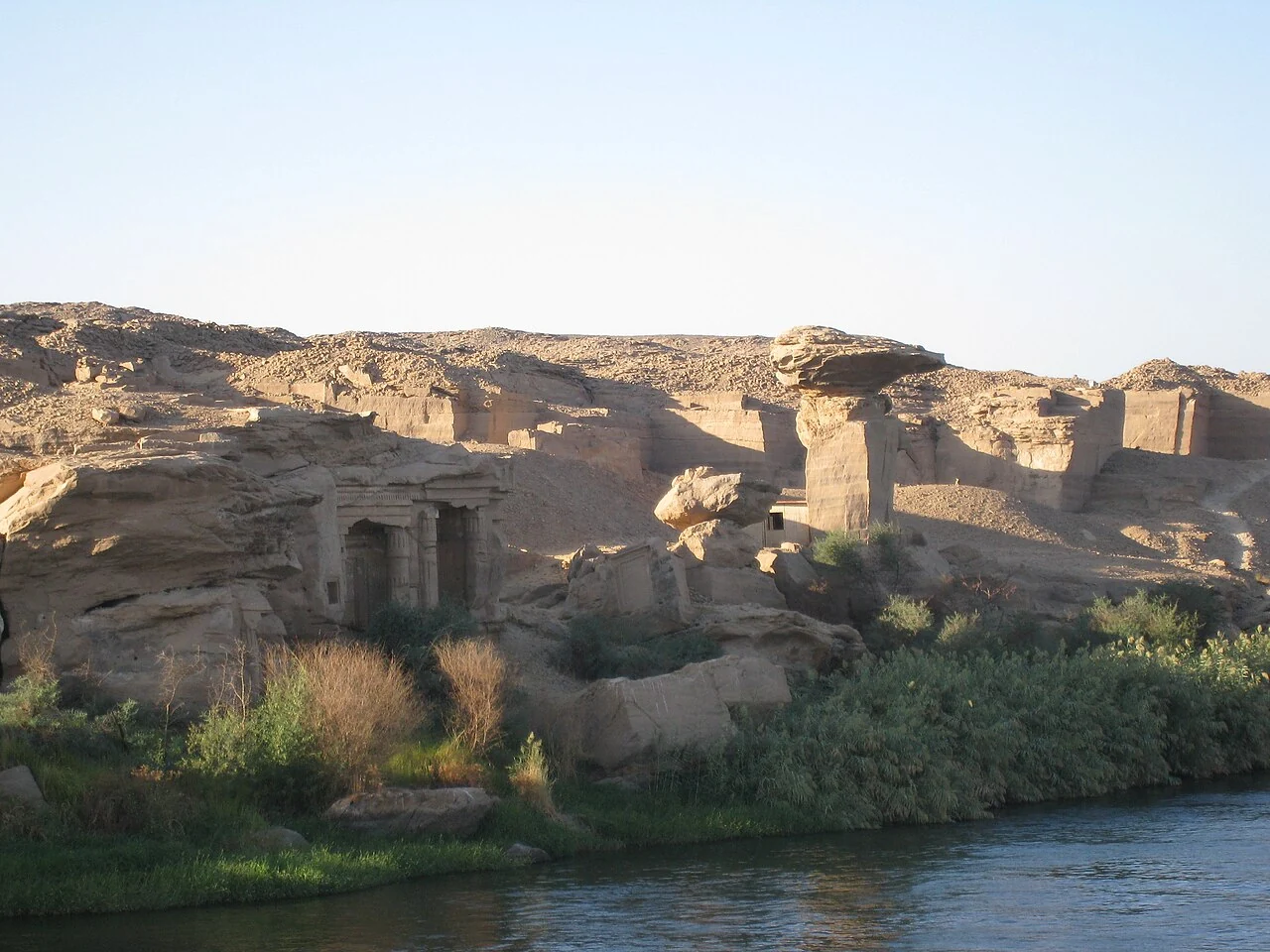
Gebel el-Silsila is a sandstone landscape on both banks of the Nile between Edfu and Kom Ombo, in the Aswan region. The river narrows between extensive rock formations, and the exposed beds made this stretch important to quarry workers over many centuries. It is misleading to describe the place as one temple or a single excavation trench. The archaeological record covers both riverbanks, working areas, cliff inscriptions, shrines, chapels, quarry faces and later reuse. The Egyptian Ministry of Tourism and Antiquities documents more than one hundred quarries and a long history of extraction. The ancient toponym is commonly rendered Kheny or Khenu, but inscriptions and later travel names should be associated with the dates in which they appear.
A map point placed in the center of the site is only a regional locator. Individual quarry marks or chapels need much more precise, documented contexts before they can be linked to that dot. Modern boats passing the cliffs, present paths, and restored or conserved monuments belong to the contemporary landscape. They cannot be used as direct evidence for every ancient access route. The archaeological attraction is precisely this overlapping record: a landscape of work and worship that changed substantially from the Middle Kingdom through the Greco-Roman period and beyond.
Why sandstone mattered to Egyptian building projects
Much of Upper Egypt’s monumental architecture relied on locally or regionally available sandstone, and Gebel el-Silsila was among the most significant sources. The rock could be cut into large blocks for architectural use, but the ease or difficulty of a quarry operation depended on bedding, flaws, block dimensions and the arrangement of labor. Sandstone does not carry a label naming the temple for which every ancient block was intended. Researchers investigate cutting marks, inscriptions, historical building phases and geological properties to study the supply of materials. A surviving quarry face may show different periods of work, with later workers extracting material beside earlier cuttings.
Popular accounts sometimes turn the site into a simple story in which one enormous quarry supplied all temples in Egypt. The field record is more complicated. Egyptians used numerous stone sources, and the choice of material depended on architectural purpose and regional conditions. The important question is not simply how much stone a quarry produced, but when, where and under whose administration extraction was organized. Different scales of evidence, from a quarry wall to a datable royal inscription, can support different levels of historical reconstruction.
From the Middle Kingdom to later reuse
The Ministry of Tourism and Antiquities places the beginning of known exploitation in the Middle Kingdom and notes that activity continued into much more recent times. A chronology of quarrying must distinguish evidence for a particular period from the lifetime of the landscape as a whole. Middle Kingdom inscriptions are present, as are the prominent New Kingdom shrines. Late and Greco-Roman texts add further phases. A stone-cut surface is not necessarily datable solely from how weathered it looks, especially where modern quarrying, conservation or erosion has altered it. Archaeologists rely on relationships between cuttings, inscribed names and the wider site sequence.
This chronological breadth makes the place useful for studying continuity without assuming an unchanging quarry organization. A pharaoh of the Eighteenth Dynasty, a Roman-period official and a modern traveler might all leave traces in the same region, but they did not inhabit one political system. Identifying those layers is central to an honest interpretation. Even where activity in two eras involved similar stone or tools, administrative demands, religious dedications and transport destinations might have differed substantially.
Quarry 34 and systematic archaeological mapping
A 2015 research publication by Maria Nilsson, John Ward, Adrienn Almásy and Sarah Doherty analyzes Quarry 34, also called the Main Quarry, on the east bank. Its methodology combines epigraphic recording with archaeological topography. Such a project records where inscriptions, quarry surfaces and visible traces stand in relation to each other. The location of a mark can matter as much as its shape: a sign next to a work face may have a different archaeological context from a commemorative inscription by a passage. Publication of the recorded features allows researchers to challenge or refine interpretations.
Quarry numbers are modern survey tools and should not be confused with ancient administrative names. The Main Quarry is an important component of the wider complex, not a stand-in for every working area. A responsible digital atlas should give a site-level description and point toward the excavation report for individual loci. It should not copy precise modern maps into invented ancient transport diagrams or assign the identity of an unrecorded worker to a random chisel mark.
The Speos of Horemheb on the west bank
The best-known surviving cult monument is the rock-cut Speos of Horemheb on the west bank. Egypt’s official monuments authority dates it to the reign of Horemheb in the late Eighteenth Dynasty and describes a sanctuary associated with seven deities. The shrine is evidence for a sacred landscape that existed alongside intensive stone production. It should not be interpreted merely as the workers’ break room or as a royal tomb. Religious display and administrative activity at a quarry could intersect, but the functions of particular spaces must be established from their architecture and inscriptions rather than from modern expectations.
The Ministry also describes two temples of Horemheb’s reign at this place, of which only one survives. Loss and preservation therefore affect the story visitors encounter. A photograph of the remaining speos cannot represent the whole original ritual topography. The damaged or vanished monument should be acknowledged in scholarly interpretation without drawing a highly detailed reconstruction unsupported by published architectural plans. Images of the extant façade can document conservation status and visible forms; they do not disclose ceremonies that left no written record.
Officials’ chapels and royal monuments
South of the speos, the west-bank cliff preserves dozens of rock-cut chapels associated with New Kingdom high officials, including individuals contemporary with Hatshepsut and Thutmose III. Nearby are monuments and inscriptions of later kings, among them Sety I, Ramesses II, Merenptah and Ramesses III. The official record mentions thirty-two chapels, but a count in modern inventory does not mean every chapel is intact, equally accessible or securely understood. They were created in a landscape used for quarrying and for commemorating the relationship between the Nile, kingship and officials.
A chapel name and a historical office can offer clues about people using the area. Yet even a named official should not be automatically described as the manager of every quarry on both banks. The texts must be read for what they actually claim. Different reigns introduced new monuments and reused existing locations. This makes the site an especially rich source for studying how a productive landscape could also become an arena for elite memory and royal statements.
Middle Kingdom graffiti and the names of workers
Research on Middle Kingdom rock inscriptions at Gebel el-Silsila has documented texts in the sandstone along a route traditionally associated with the Middle Kingdom and near the New Kingdom chapels. A peer-reviewed Journal of Egyptian Archaeology paper by Maria Nilsson and colleagues discusses inscriptions preserving administrative and official titles. The significance is not that every graffito provides a diary of a quarry laborer; rather, particular titles help place named officials within patterns of work and movement. Their dates and contexts allow comparison with broader Middle Kingdom administration.
Graffiti must be treated as inscriptions of varying purpose. Some may be informal, others carefully composed, and their physical positions may signal practices now difficult to reconstruct. Identifying a rock mark as a hieroglyphic sign requires caution, because scratches, quarry marks and ordinary geological surfaces can resemble symbols. The scholarly project separates these questions instead of declaring every unfamiliar line a lost secret script. This is an important example of how careful recording produces better historical knowledge than visual speculation.
Tools, quarry marks and the mechanics of extraction
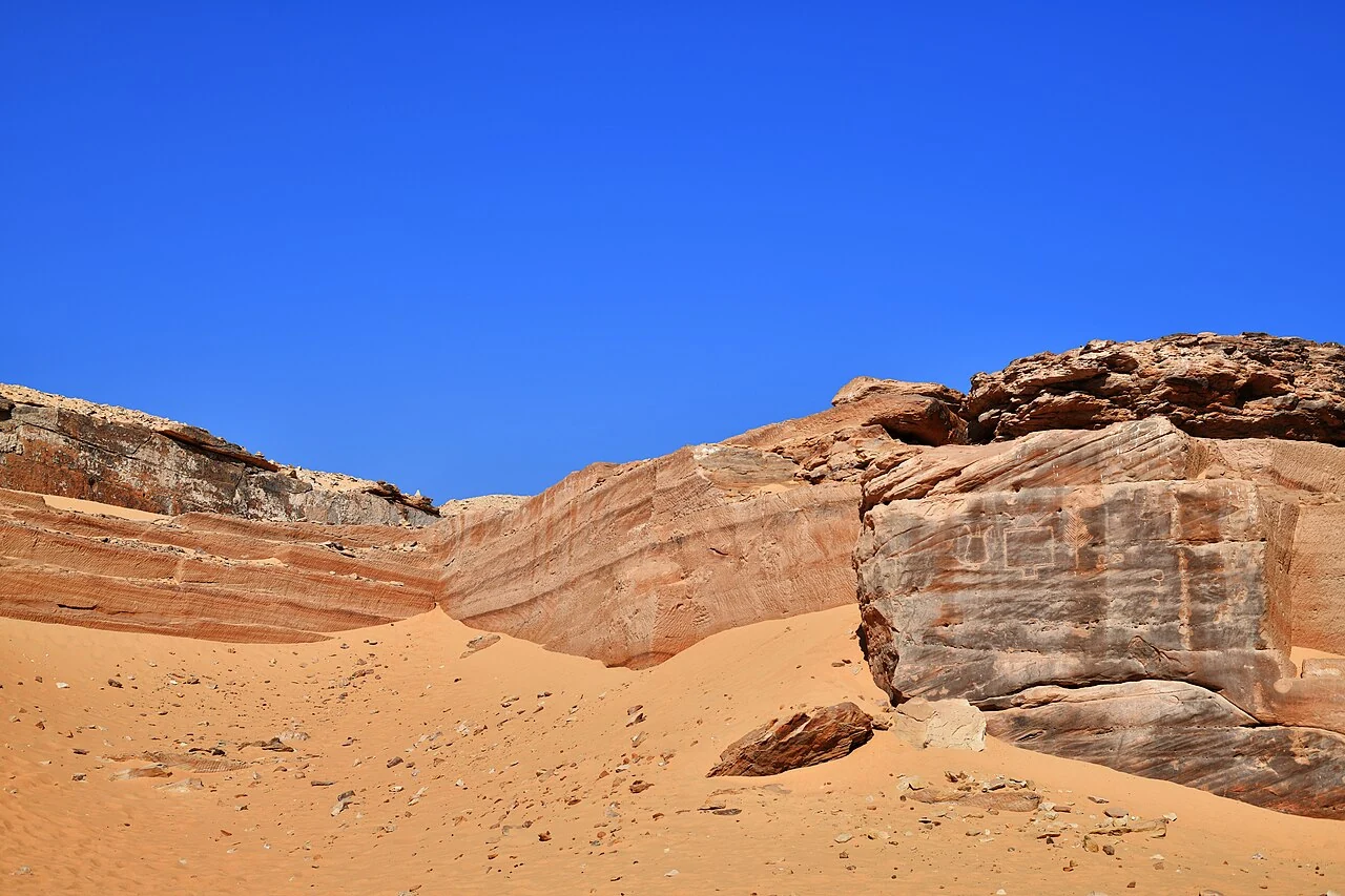
The material evidence of extraction includes cut faces, channels, discarded or unfinished stone and tool marks. Analysts can study how blocks were isolated from bedrock and which surfaces were worked before transport. The traces sometimes preserve the sequence of cutting, but a photograph on its own cannot establish the date or the exact kind of tool. Stoneworkers may have returned to an existing quarry and removed or reshaped earlier traces. Comparing the archaeological surface with documented quarry techniques and ancient inscriptions is therefore more reliable than judging from a dramatic image of a straight-edged wall.
Claims about the impossibility of ancient stoneworking often ignore the range of labor, transport and tool systems available over many centuries. Equally, the presence of tool marks does not justify precise estimates of each crew’s daily output without calculations based on dated evidence. The project investigates the production landscape as a network of linked activities, including the movement of extracted blocks toward the Nile. A defensible explanation identifies what is observed, what the team proposes and which steps remain hypothetical.
The Nile as transport corridor
The river beside Gebel el-Silsila helps explain why this quarrying region mattered. Moving heavy stone toward major building sites required transport solutions, and the Nile provided an extensive north-south corridor. However, present-day river levels, channels and docking points cannot be treated as exact replicas of their ancient counterparts. A quarried block might follow temporary routes on land before reaching a boat, and the archaeological survival of those routes is uneven. Modern images of vessels passing the cliffs show the river environment but not the dimensions or operational procedures of any New Kingdom quarry fleet.
It is reasonable to see a relationship between accessible stone and the river, but not to draw a fully measured shipping timetable from an undated rock cutting. Researchers combine quarry topography, inscriptions, stone studies and documented monuments elsewhere to understand procurement. The archaeological atlas should therefore distinguish the river corridor from individual routes that may be reconstructed in scholarly publications. This careful handling makes the site more useful for understanding the interaction of geology, administration and architecture.
Roman-era quarrying and the god Min
The quarries continued to be relevant during Roman rule. A Lund University publication by Nilsson and Almásy reports a small east-bank quarry in which named men marked repeated visits during years of the emperor Claudius. A nearby scene of Min and a demotic text provide a religious dimension to this industrial setting. This is unusually specific evidence that quarry activity continued beyond the earlier reigns often associated with the site. The inscriptions connect a dated imperial framework with individuals and a local protective deity, without requiring a claim that every nearby quarry was active at the same moment.
This evidence also complicates the idea of a sharp cultural break after the end of the pharaonic dynasties. The quarry landscape acquired new political labels while Egyptian gods and inscriptions still mattered. It would nevertheless be misleading to call the whole site Roman or to treat the Claudian evidence as the final definite date of quarrying everywhere. Other working phases and later traces need independent study. The value of this particular find lies in the intersection of personal names, dates and a documented working place.
Interpreting the site photographs responsibly
The photographs in this article show the actual Gebel el-Silsila landscape and its sandstone quarry surfaces. One image was released to the public domain by its photographer, while the second was shared under Creative Commons Attribution-ShareAlike terms. Each image is reproduced with its source and credit, then converted to a local WebP for the article. Neither picture is presented as an ancient reconstruction, and neither alone establishes the precise chronology of the visible cuts. The captions distinguish the modern viewpoint from the historical interpretation.
At major archaeological complexes it is easy to use one impressive view to illustrate the wrong chapel or excavation zone. For that reason, photographs here carry only identifications supported by their Commons source records. Claims about the Speos of Horemheb, Quarry 34 and the Roman inscriptions are sourced to the Ministry and research publications rather than assigned to features the photograph may not show. Good visual documentation can guide a visitor to read further while avoiding the false precision of a speculative label.
What the archaeological record answers, and what remains open
Gebel el-Silsila gives strong evidence for long-lived sandstone extraction, royal and official commemorative monuments, and inscriptions spanning several political periods. Field surveys are expanding the record of quarry locations, rock art, ancient pathways and administrative activity. Important questions remain about the changing scale of extraction, the assignments of individual blocks to distant temples and the organization of workers. The discovery or re-reading of inscriptions may alter established chronology, making dated citations valuable. The difference between a verified named inscription and an inferred operating practice should always remain visible.
The site is worth studying both as an industrial landscape and as a sacred one. A map should not reduce its complexity to a single monument icon, and a history article should not treat every phase as though it occurred during Horemheb’s reign. Readers interested in moving from the site to an understanding of Egyptian cultural geography can compare its quarrying corridor with the archaeological atlas and with the royal monuments of the Nile Valley. Those links help situate the evidence rather than imply that all visible structures were produced by one builder.
Site evidence at a glance
| Type of evidence | What it establishes | Limit of interpretation |
|---|---|---|
| Quarry working faces | Repeated sandstone extraction and visible cutting activity | Not all cuts are independently dated |
| Horemheb’s speos | Surviving rock-cut religious monument | Does not represent both original temples |
| Official chapels | Commemorative activity in the New Kingdom | Cannot assign every official to every quarry |
| Middle Kingdom inscriptions | Administrative titles and named individuals | Not a complete census of quarry labor |
| Claudian marks and Min | Roman-period working and religious associations | Not evidence that all quarries remained active |
Primary and institutional research references
For exact monumental inventories and historical dates, consult the Egyptian Ministry of Tourism and Antiquities. For quarry-by-quarry interpretation, use published field reports rather than unsourced modern photographs.
- Egyptian Ministry of Tourism and Antiquities, Gebel al-Silsila.
- Nilsson, Ward, Almásy and Doherty, Gebel el Silsila: Field report from the Main Quarry (2015).
- Nilsson and Almásy, Quarrying for Claudius, protected by Min (2015).
- Oxford University, Artefacts of Excavation, Gebel es-Silsilah.
- Gebel el-Silsila Archaeological Project: survey and conservation.
Review completed 2 November 2026. All photographs show real landscapes documented on Wikimedia Commons, and images have independently inspected usage rights. Exact present-day visitor arrangements are not inferred from the archaeology.