What is Bab Zuwayla in Cairo? Bab Zuwayla, or Bab Zuweila, is the southern gate of Fatimid Cairo, built under Badr al-Jamali in 1092 CE. Its two towers later supported Mamluk minarets built in 1415–1421, and the gate became associated with the execution of Tumanbay after the Ottoman conquest in 1517.
This page examines a single named monument using the Egyptian Ministry of Tourism and Antiquities’ heritage record. Its date, alternate names, architecture, conservation and visitor access are documented separately from the al-Muizz walking route and the political history of the Ottoman conquest.
Bab Zuwayla: the gate that connects three eras of Cairo
Bab Zuwayla stands at the southern end of al-Muizz Street, one of the surviving gates of Fatimid Cairo. Its historical importance reaches far beyond one dynasty: the gate was built in the late eleventh century, became associated with a Mamluk mosque whose minarets stand above it, and later witnessed events during the Ottoman conquest of Egypt in 1517. A visitor looking at the structure today can encounter a physical object that links Fatimid engineering, Mamluk architecture and the political upheavals of early modern Egypt.
The Egyptian Ministry of Tourism and Antiquities provides an unusually precise institutional record for Bab Zuwayla, including the year 1092, the original design, later minarets, alternate names and recent conservation. This gives us a clear source for a named heritage entity rather than a generic claim that all Cairo gates are identical. The purpose of this study is to examine the actual gate, not duplicate an entire walking itinerary or the story of Selim I’s campaign.
1092: Badr al-Jamali’s southern stone gate
The Ministry dates Bab Zuwayla to 485 AH/1092 CE during the reign of the Fatimid caliph al-Mustansir, under the direction of vizier and commander Badr al-Jamali. This was several years after the northern stone gates of Bab al-Futuh and Bab al-Nasr. The earlier foundation of Cairo in 969 belongs to a different construction phase; it would be misleading to claim that the gate seen today was raised in the exact year the capital first appeared.
Badr al-Jamali’s fortification work reflects the changing defensive needs of a major city and its expanding neighbourhoods. The walls and gates were designed as substantial stone structures rather than simply decorative entrances. Surviving towers, passage geometry and masonry provide material evidence of this campaign. The site’s connection with a tenth-century capital is real, but its surviving main gate is an eleventh-century monument.
What does the name Zuwayla mean?
The Ministry explains that the gate was named after the Zuwayla tribe, associated with Berber or North African groups who accompanied Jawhar al-Siqilli and settled near the site. This illustrates how urban names can preserve the memory of people and neighbourhoods rather than describing only a building’s architectural form. The name of a gate can remain even when its physical structure is rebuilt.
The name is also recorded in variant English transliterations such as Bab Zuweila, Bab Zuwayla and Bab Zuwaila. These are largely spelling conventions representing the Arabic باب زويلة; they should not automatically become separate website pages with duplicate content. A sound SEO and historical strategy selects one canonical form and explains alternatives on the same page. The variations are useful to visitors, but they do not imply three distinct Cairo monuments.
The gate’s two semi-circular towers
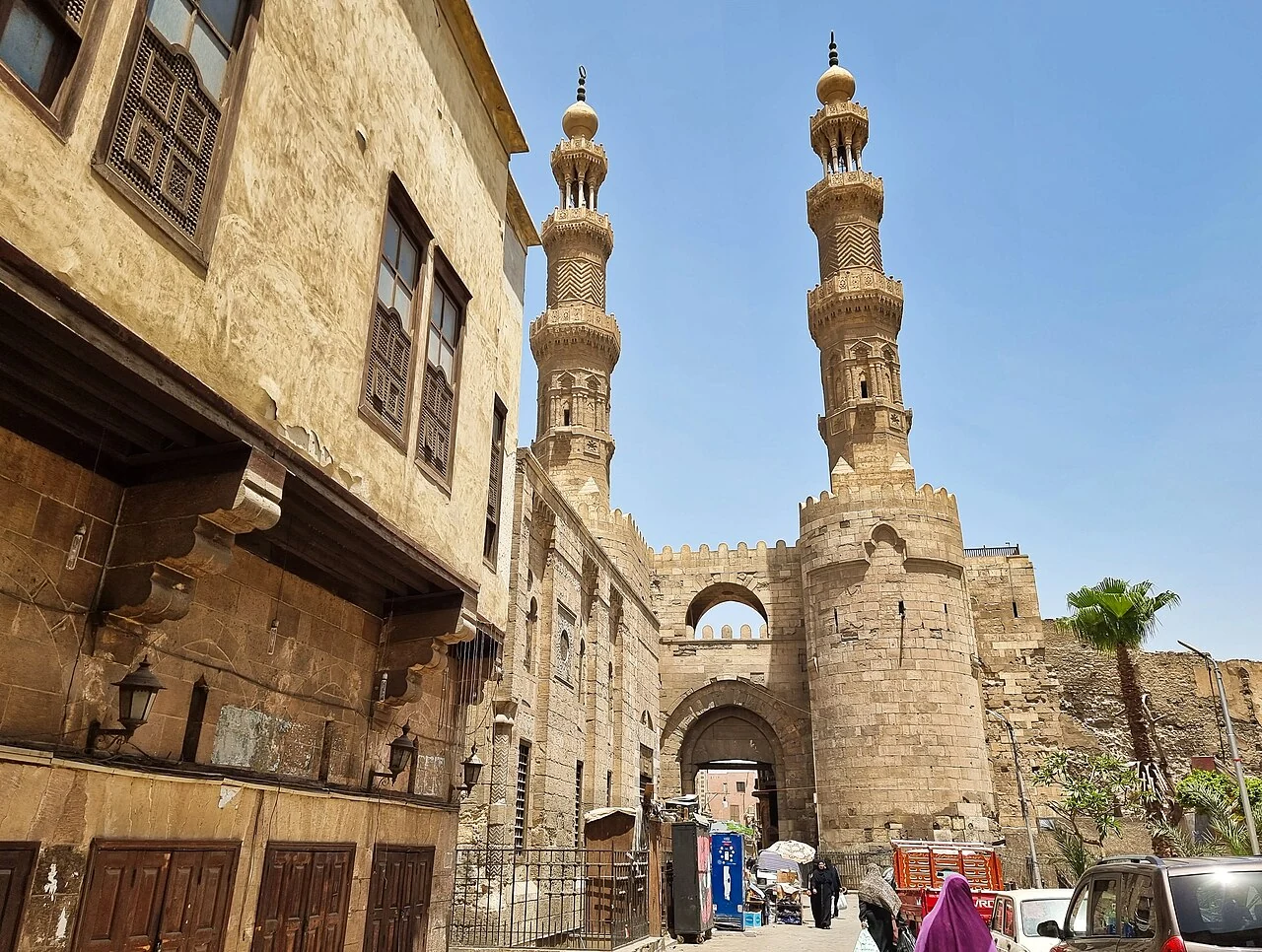
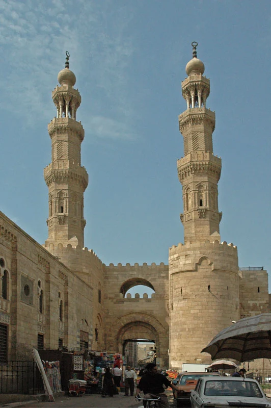
Bab Zuwayla’s most distinctive defensive features include two semi-circular stone towers with a central entrance. The Ministry specifies an entrance width of approximately 4.82 metres. This is a measurable physical detail, not a symbolic number discovered through modern numerology. The structure’s form reflects the practical engineering of a fortified urban passage: movement could be guided and controlled while towers helped protect the approach.
Much of historic Cairo’s architecture has been altered or restored, so a visitor should not assume that every visible stone surface has remained untouched since 1092. A reliable architectural study distinguishes the original plan, later additions and modern conservation. Comparing the gate with Bab al-Futuh or Bab al-Nasr can reveal broader Fatimid design decisions, but their towers and carved decorations should be described on their individual archaeological records rather than copied from one another.
From a military threshold to an urban landmark
A city gate was a controlled passage between areas of a capital. It also acquired administrative, social and symbolic uses over centuries, especially as urban life expanded beyond the defensive walls. Bab Zuwayla’s location at the end of the historic al-Muizz axis made it an important point of reference for residents, merchants and later visitors. Its name could carry meanings beyond its original defensive purpose.
The gate’s survival makes it possible to reconstruct its spatial role, yet a modern city street does not replicate the traffic and security practices of the Fatimid court. Archaeological plans, inscriptions and historical texts are required to understand how the gate was operated in its first century. A photograph can show masonry and the opening visible now, but it cannot by itself establish the rules of passage followed by people a thousand years ago.
The Mamluk minarets above the Fatimid towers
During the reign of Mamluk Sultan al-Mu’ayyad Shaykh, the bases of Bab Zuwayla’s towers were incorporated into a new religious architectural composition. The Ministry states that the two minarets were constructed in connection with the sultan’s mosque between 1415 and 1421 CE. This is a striking example of architectural reuse: a surviving Fatimid defensive structure became an important part of a later Mamluk religious landmark.
The minarets are therefore not original eleventh-century towers, even though they rise from them. Their presence creates a layered skyline that often confuses casual photo descriptions. A careful caption identifies the medieval gate and Mamluk additions without assigning them a single construction date. Such layered monuments are one of the reasons Cairo is so valuable for studying different periods of Egyptian history on a single street.
Bawabat al-Mitwalli: another name for the site
Bab Zuwayla has also been called Bawabat al-Mitwalli, a name connected in the Ministry’s record with the official known as the Mitwalli al-Hisba. Administrative associations can persist in urban place names long after the precise office or its functions have changed. The alternative name helps explain why a local description may differ from the wording used by an international travel guide.
Using the historical names with their context is better than generating several identical web pages for each spelling. The same monument and its UNESCO setting remain unchanged when a visitor encounters Bab Zuweila, Bab Zuwayla or Bawabat al-Mitwalli. For research, the named Arabic location and verified Ministry record are stronger identifiers than whichever Latin spelling happens to rank best in a search engine that month.
Tumanbay’s execution in 1517
Bab Zuwayla is closely connected with the end of the Mamluk sultanate. The Egyptian Ministry records that Tumanbay, the final Mamluk sultan, was executed at the gate following the Ottoman conquest in 923 AH/1517 CE. This dramatic later association made an earlier Fatimid monument part of the memory of a political transition. It did not change the gate’s original date of construction.
Tumanbay’s defeat and execution formed part of a wider military and administrative conflict involving Selim I, battles in Syria and Egypt, and the creation of an Ottoman provincial system. Kemet Vault’s separate source-based Ottoman conquest dossier explains those events. This Bab Zuwayla page has a narrower intention: the location, architecture and changing functions of one authentic urban monument. The documentary photographs are views from the twenty-first century, not pictures of the execution.
How the gate was conserved in the 1990s and 2000s
The Ministry identifies conservation activity beginning in the 1990s, with a later project undertaken with the American Research Center in Egypt between 1998 and 2003. Such interventions are part of the documented life of the monument. A restored tower may preserve original masonry alongside repaired sections, and conservators must address structural stability, weathering and the effects of continued urban use.
The existence of a conservation campaign does not imply that everything visible in a modern photo is new or that the original gate was completely reconstructed from scratch. Equally, a photograph of an attractive facade should not be described as an untouched eleventh-century surface unless individual features are identified by a technical record. Responsible heritage interpretation tells the story of restoration rather than hiding it behind a timeless image of medieval Cairo.
Two independent photographs of the real gate
The first photograph accompanying this article was taken by Richard Mortel in April 2022 and shows Bab Zuwayla from a documented Cairo street viewpoint. It was released under Creative Commons Attribution 2.0. The second photograph was made in May 2008 by Baldiri and shared under CC BY-SA 3.0. They are separate original source files, created by different photographers more than a decade apart.
Both are authentic visual records of the actual site rather than generative images of a presumed Fatimid battle. The dates in their captions refer to when the pictures were taken, not to the construction of the gate or the erection of the minarets. The images help distinguish the two towers and the surrounding later architecture, while the Ministry’s archaeological record provides the necessary dates. Local WebP hosting can improve page delivery while retaining their attribution and reuse terms.
What is the difference between Bab Zuwayla and Bab al-Futuh?
Bab Zuwayla stands on the southern side of the historical walled city, while Bab al-Futuh and Bab al-Nasr belong to the northern wall. The Ministry dates the northern stone gates to around 1087, with Bab Zuwayla constructed about five years later in 1092. The surviving gates form parts of the same broader defensive campaign but occupy different locations and feature specific architectural details.
For a general journey from the north to the south of the district, visit Kemet Vault’s Al-Muizz Street route. That guide helps readers choose which places to explore, while the present article serves those seeking the precise history of Bab Zuwayla itself. The differentiation is intentional: location-specific heritage records should inform a travel plan without forcing the entire historical detail of every gate into one itinerary article.
Is Bab Zuwayla part of Historic Cairo’s heritage landscape?
Bab Zuwayla is one of the important monuments within the wider historic urban fabric of Cairo. UNESCO’s Historic Cairo designation covers an extensive ensemble of religious, civil and defensive architecture from multiple periods. Being within that ensemble is not the same as saying that Bab Zuwayla received an entirely separate World Heritage inscription under its own independent listing.
The monument’s heritage value comes from its physical fabric, historical associations and relationship to the city, but a place with international recognition can still need practical conservation and careful visitor management. Public interest does not eliminate risks from weather, urban pressure or inappropriate access. The strongest way to appreciate the gate is to connect its known physical features with the dated phases supplied by the archaeological record, while recognising the living neighbourhood around it.
Visitor access, tickets and responsible photography
The Egyptian Ministry of Tourism and Antiquities lists an admission arrangement for Bab Zuwayla, but ticket amounts and access details can change. Anyone planning to enter the tower or associated interior areas should consult the current official monument page before travel. Passing through a public street and entering a conserved monument are different activities, and one cannot assume unrestricted access based only on a location appearing in a guidebook.
The site remains part of a working urban environment. Visitors should respect other people, safety barriers and conservation restrictions, and avoid touching damaged stone or climbing closed sections. A good photograph does not require inventing a scene from 1517; the real gate is visually and historically distinctive. Accurate captions, known dates and a genuine architectural explanation make the image more valuable to a student, tourist or researcher.
A named monument as a model for evidence-led heritage pages
Bab Zuwayla illustrates how an Egyptian heritage site can be documented as a unique entity rather than a mass-produced location page. Its official record establishes the name, alternate spelling, date, patron, location, structure, later religious additions and documented conservation. Those facts allow readers to follow distinct questions about architecture, urban memory and the Ottoman conquest without generating a separate page for every trivial keyword variation.
This is an appropriate model for a carefully supervised heritage entity programme across historic Egypt. The value comes from a verified physical monument and its distinctive source record, not from substituting a different gate name into the same template. Kemet Vault will retain its broader medieval Egypt gateway and the route guides as separate contexts while the individual gate article provides the fuller evidence for this one location.
Primary Egyptian heritage record and verifiable sources
All key architectural dates and identities are grounded in the Egyptian Ministry of Tourism and Antiquities’ Bab Zuwayla record, which documents the gate’s construction, towers, minarets and restoration. The wider city-wall context follows the Ministry’s Walls of Cairo record, while the UNESCO Historic Cairo listing establishes the wider heritage setting. These sources also explain why modern ticket information must be checked directly rather than treated as permanent. Both site photographs retain their own date and licence records.