The ancient Nile Delta was Egypt’s shifting northern landscape: a network of river branches, fertile floodplains, marshes, towns and sanctuaries that looked different from the two-branched Delta on modern maps. Its waterways shaped where people lived, how goods moved, how fields were cultivated and even how political centres rose and declined. Research at cities such as Bubastis and Buto has made the picture more precise, showing the value of sediment cores and archaeology over assumptions inherited from older schematic maps.
A changing river, not a permanent triangle
The Nile Delta is often represented as a neat green triangle with two river mouths. That image describes part of today’s geography, but it is a poor model for understanding the places where ancient Egyptians lived. The river shifted across a low, sediment-rich plain, creating distributaries, natural levees, wetlands and channels that could grow, migrate or become clogged. Villages and religious centres developed in response to those waterways, not according to a permanent modern administrative map.
Scientific reconstructions combine sediment cores, topography, electrical-resistivity surveys and archaeological remains. They suggest that the positions of channels changed across centuries and millennia; maps of the Delta for one dynasty should therefore not be reused uncritically for another. Water shaped transport and agriculture, but changes in water supply could also force people to modify a settlement or relocate.
The modern Rosetta and Damietta branches are only the remaining major distributaries. Ancient writers described as many as seven, a count that reflects their own periods and classifications rather than a simultaneous network always containing precisely seven equally sized rivers.
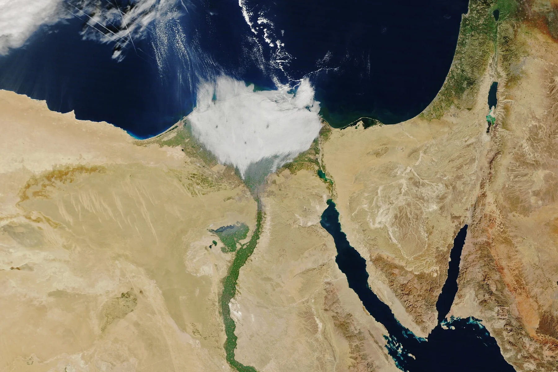
Where the Nile Delta begins and how it was formed
North of the narrow Nile Valley, the landscape opens toward the Mediterranean. Sediments carried downstream built a broad lowland through repeated deposition and channel movement. Over long periods, sand, silt and clay accumulated in alternating environments: open river courses, quiet marshes, flood basins and higher levees.
The Delta’s exact margins depend on whether researchers define them by geomorphology, modern cultivation, ancient wetlands or administrative boundaries. A frequently cited scholarly estimate places the deltaic system at approximately 24,000 square kilometres. This is a regional research estimate, not a constant measurement that applies unchanged to every prehistoric or historical moment.
The surrounding desert and coastal lakes formed ecological boundaries but also places of exchange. Ancient Egyptians used waterways for movement between urban centres, fields, sanctuaries and Mediterranean approaches. Boats were necessary infrastructure, not merely funerary symbols.
Seven ancient branches versus the two modern channels
Classical sources supply names usually rendered as the Canopic, Bolbitine, Sebennytic, Phatnitic, Mendesian, Tanitic and Pelusiac branches, but reconstructions vary. The list does not provide a single fixed map for the entire pharaonic era. Some distributaries shifted or dwindled while others were active, and a classical author’s geography should be placed within that author’s date.
Modern geography centres on the Rosetta branch to the west and Damietta branch to the east. Their present shape is the outcome of long-term natural and human-controlled river changes. Scholars compare ancient written testimony with palaeochannels detected beneath fields to understand what connected specific settlements to river traffic.
The eastern Delta in particular contains traces of former Tanitic and Pelusiac water systems. Their changing alignments affected where towns could prosper and where imported goods could be carried from the Mediterranean or the Levant into the Nile interior. A line on a historical map is therefore an interpretation with evidence behind it, not a surviving open river that one can always follow today.
Flooding, alluvial soil and agricultural life
The Nile brought water and sediments that supported agriculture, but the floodplain was never a risk-free paradise. Productive cultivation required knowledge of seasonality, soil, drainage and local conditions. Communities took advantage of rich flood basins while trying to protect houses and stores from inundation.
Higher river levees and sandy elevations called geziras offered safer places for settlement. Lower surrounding ground could supply cultivated or grazing land when conditions allowed. Archaeological landscapes can preserve traces of this division even when the terrain now looks uniformly level because of modern cultivation and development.
An especially useful question is not simply how floods helped Egypt, but why different areas had very different opportunities. A town located near a navigable channel might gain transport and trading advantages while facing problems from a channel that migrated closer to buildings or retreated too far for practical use.
Bubastis: a city built around landforms and waterways
Bubastis, near modern Tell Basta in the southeastern Delta, offers unusually valuable scientific evidence. The city is known for its temple of Bastet, administrative significance and long occupation. Recent geoarchaeological studies investigate how raised sand mounds and low floodplain surfaces shaped the urban area.
A 2025 open-access research article describes surveys using coring and electrical-resistivity methods. It identified different kinds of sedimentary deposits, elevated Pleistocene sand formations and contrasts in ancient occupation. Some thicker anthropogenic sequences reflect particularly dense later habitation, while other areas seem to have remained less built up and more suitable for agriculture.
The results matter because they replace an oversimplified idea of an ancient city built on a single flat site with a more complex network of habitable high ground, waterways and surrounding fields. They do not prove that the exact function of every buried structure is known, and the maps remain dependent on sampling and interpretation.
Buto, Sais, Tanis and Mendes: four different Delta stories
The northwestern Delta site of Buto is important for understanding settlement in relation to shifting waterways. Sais became a prominent centre in the Late Period, yet its historical importance cannot be described exclusively through the history of one dynasty. Tanis, in the northeastern Delta, is famous for monumental material and royal burials, while Mendes has its own long religious and political record.
These sites did not form one unchanging chain of capitals. Their trajectories differed, and the waterways connecting them were not static. Modern names, ancient Egyptian names and Greek versions also require care: two place names may refer to the same settlement in different texts, while apparent geographical parallels can conceal real differences.
To understand an individual city, begin with its recorded material and date, then ask what kind of floodplain, channel or nearby higher ground made the site viable. The Nile Delta is a landscape of local histories rather than merely the northern end of the Nile.
Delta cities and Mediterranean connections
Branches of the Nile linked Egypt’s interior to coastal zones, exchanging agricultural products, building materials, people and ideas. The Delta also stood between Egypt and the eastern Mediterranean world, so control of channels and access points mattered for commerce and defence.
These connections changed during the pharaonic, Greek and Roman periods. Ports and trade routes were affected by sediment deposition as well as political conditions. An old town’s decline may reflect multiple causes, and researchers should not claim a river moved and therefore a city collapsed without the relevant excavation and environmental evidence.
Historical geographers use ceramic distributions, imported objects, written documents and reconstructed water routes together. No one dataset supplies a complete map of all trade connections.
How researchers find buried rivers
Modern satellite images display today’s cultivation pattern, not the full ancient river network. To investigate older systems, archaeologists examine elevation models, sediments taken in cores, geophysical measurements and changes in grain size. Fine silts can suggest quieter settings, while sandier sequences may belong to more energetic water movement. Each observation must be interpreted within a local sedimentary context.
Electrical-resistivity methods can detect contrasts under the surface, though groundwater and soil composition can blur the readings. Geoarchaeologists then compare these results with pottery, building phases or radiocarbon evidence when available. Dates and locations must be tested rather than deduced solely from the attractive shape of a line in an image.
This is why the most useful maps make uncertainty visible. A reconstructed ancient watercourse may be shown as probable, approximate or disputed. Students should read the map legend and the accompanying publication before copying a channel into a historical atlas.
The Delta today is not a snapshot of ancient Egypt
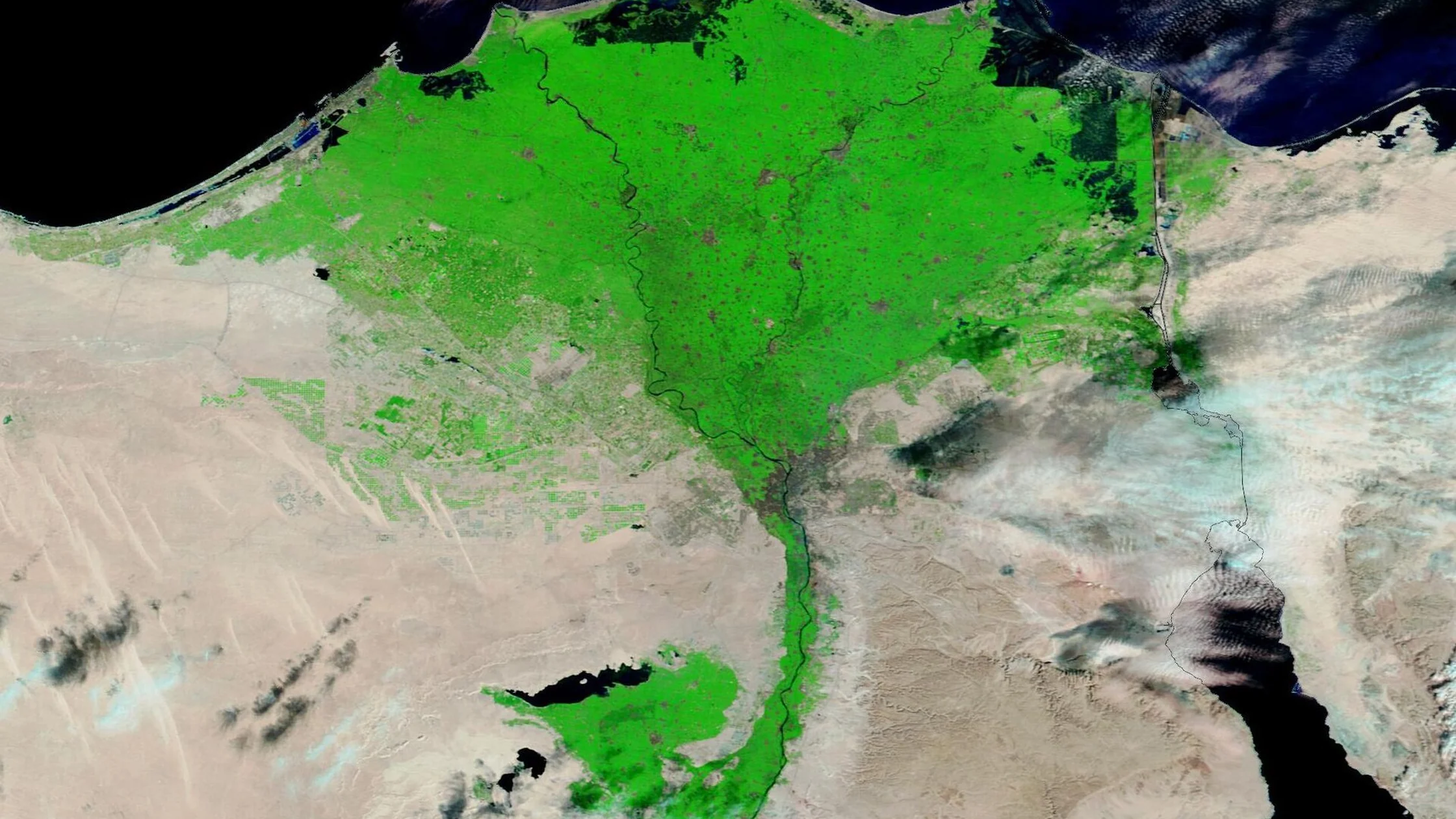
The completion of the Aswan High Dam transformed the seasonal movement of Nile water and sediments. Modern irrigation, drainage, urban growth and coastal change have further altered the visible landscape. The green region seen in a recent satellite photograph should not be represented as an accurate photograph of the Delta in the Old Kingdom.
Coastal lagoons, agricultural fields and built-up towns now occupy areas that changed repeatedly in the past. Archaeological evidence may lie below modern settlements, creating challenges for excavation and conservation. A responsible history page distinguishes a present-day geographical image from a scientific reconstruction of ancient channels.
Climate change, coastal erosion, saltwater intrusion and population pressure also affect the present region. These current concerns deserve separate environmental analysis rather than being projected backwards as explanations for every ancient settlement event.
What an ancient Egyptian map of the Delta can and cannot tell us
There is no single surviving ancient map that depicts the full Nile Delta with the accuracy of a modern survey. Inscriptions, itineraries, classical descriptions and site excavations supply partial perspectives. Every reconstruction combines evidence from different dates and methods.
The safest approach is to distinguish three layers: documented archaeological sites, estimated historical waterways and present-day roads or rivers. Each layer answers a different question. If an ancient branch cannot be securely mapped to a specific dynasty, marking that uncertainty is a strength rather than a failure of the research.
For a wider view of Egyptian history see the Fourth Dynasty state study, and for a recent local discovery within the Delta see the Behbeit el-Hagar royal statues report. Those pages ask different historical questions.
Frequently asked questions
How many branches did the ancient Nile Delta have? Classical sources describe up to seven major branches. These did not necessarily all function in the same form or at the same time; modern Egypt has two main Delta distributaries, Rosetta and Damietta.
What does ‘Lower Egypt’ mean? It conventionally refers to northern Egypt, including the Delta. ‘Lower’ describes the downstream course of the Nile toward the Mediterranean, not lower importance.
Why did ancient Egyptians build on geziras? Raised sandy ground often offered a more flood-resistant setting for houses and significant buildings than surrounding lower flood basins.
Can we see lost Nile channels today? Some traces can be reconstructed using sediment studies, remote sensing and archaeology; a former channel may no longer exist as visible open water.
Was the Delta always fertile? Many areas supported agriculture, but conditions differed across place and time. Water levels, sediment, salinity and settlement changes all mattered.
Primary research and photographic source
Meister, Lange-Athinodorou and Ullmann (2021), Geoarchaeology of the Nile Delta; Garbe et al. (2025), Paleoenvironmental Reconstruction of Bubastis; Garbe (2026), landscape evolution around Bubastis; Research on northwestern Delta settlement patterns.
Featured photograph: authentic NASA MODIS satellite observation of the Nile Delta from January 2026, source photograph and public-domain documentation. This is a present-day satellite photograph, not a reconstruction of an ancient landscape.